Pole Mountain Preserve Prescribed Fire

Prescribed burn planned at Sonoma Land Trust’s Pole Mountain Preserve west of Cazadero, Wednesday, July 12, 2023 to improve ridgeline shaded fuel breaks and support forest health

CAL FIRE Sonoma-Lake-Napa Unit
Jason Clay & Tyree Zander, Public Information Officers
707-967-4207
LNUPIO@fire.ca.gov

Sonoma Land Trust
Gina Fabiano, Director of Marketing and Media Relations
707-596-3761 cell
gina@sonomalandtrust.org

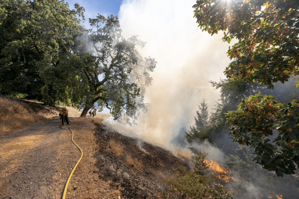
Jenner, CA – Sonoma Land Trust and CAL FIRE announced plans to conduct a prescribed burn at Pole Mountain Preserve near Jenner, California on Wednesday July 12. Totaling 16 acres, the burn will begin as early as 8:00am and will be managed by the CAL FIRE Sonoma-Lake-Napa Unit in partnership with Sonoma Land Trust. The burn is part of a larger community effort to fire resiliency throughout the region.

Ridgelines and fire-access roads are strategic locations for controlling the progression of wildfire and for the safe reintroduction of good fire as a forest health management tool. This is just one step in a multi-year effort to create a network of ridgetop shaded fuel breaks that provide multiple benefits to ecosystem health and community safety.

The prescribed burn will be among the first in the region to be conducted under the CalVTP Program, which expedites the implementation of vegetation treatments to reduce wildfire risk while conserving natural resources. This is also the first forestland prescribed burning at Sonoma Land Trust’s Pole Mountain Preserve.

The burn will be conducted by prescribed fire managers from CAL FIRE, with support from Sonoma Land Trust staff, Gold Ridge Fire Protection District, Monte Rio Fire District, and the Northern Sonoma County Air Pollution Control District.

Safety is the top priority when burning, and CAL FIRE will make the decision to burn once they have checked weather conditions and evaluated all safety protocols.

Smoke and Traffic Advisory

The prescribed burns will take place near the summit of Pole Mountain, the tallest peak along the Sonoma Coast, located between Jenner and Cazadero. The prescribed burn will commence at approximately 8:00am and conclude around 5:00pm and smoke from the burn may be widely visible. Units will continue to produce a lesser amount of smoke in the days following burning operations, and all burn sites will be monitored by fire personnel.

If you see smoke from this burn, please refrain from calling 911.

Restoring ecosystem health and wildfire resilience

Sonoma Land Trust is dedicated to restoring natural habitats and building climate resilience using nature-based solutions. These burns will improve the health of mixed hardwood and conifer forest by reducing tree density and surface fuels. Burning strategic ridgetop locations will serve as anchors for implementing the multi-stage land management plan that provides landscape-scale ecosystem health and resilience to wildfire and climate change.

This project is the result of many partnerships and planning that spanned over seven years. In 2016, CAL FIRE supported the initial multi-stage forest management planning process. Forest treatments were then implemented sequentially in partnership with the Natural Resources Conservation Service EQIP program, California Coastal Conservancy’s Wildfire Resilience Program, The Nion Robert Thieriot Foundation, and numerous contractors including Great Tree Tenders, Biswell Forestry, and Audubon Canyon Ranch’s Fire Forward program. Extra assistance was provided by generous volunteers and Boy Scout Troop 14, along with oversight and guidance from CAL FIRE.

The forestlands bordering the summit of Pole Mountain are comprised of ancient bay laurel, madrone, oak, and maple trees that are increasingly crowded by planted conifers and resprouting hardwoods following the 1978 Creighton Ridge Fire. This site is within a larger strategic fuel break plan that extends from Duncan’s Mills to Pole Mountain and down to Hwy 1 on the coast and ties into a network of neighboring fuel break projects. 

Information is available on roadway signage and via social media channels @SonomaLandTrust and @CALFIRELNU

Learn more:

The Sonoma Land Trust Living with Fire Strategy: https://sonomalandtrust.org/living-with-fire/

Sonoma Land Trust’s Pole Mountain preserve: https://sonomalandtrust.org/our-preserve-system/anchor-preserves/pole-mountain/

CAL FIRE www.readyforwildfire.org/

ABOUT CAL FIRE SONOMA-LAKE-NAPA UNIT
The California Department of Forestry and Fire Protection (CAL FIRE) serves and safeguards the people and protects the property and resources of California. The CAL FIRE Sonoma-Lake-Napa Unit, or LNU for short, is one of 21 CAL FIRE administrative units, and one of the largest. Spanning north of the San Francisco Bay Area from the Pacific Ocean to the Interstate-5 corridor, the counties of Colusa, Lake, Napa, Solano, Sonoma, and Yolo come together to form a CAL FIRE Unit. LNU has primary responsibility for 2,063,280 acres of State Responsibility Area (SRA) – the most of any CAL FIRE Unit – and a vast range of vegetation types, populations, and political climates. We staff 21 fire stations, 31 state engines, six bulldozers, operate two conservation camps, have one fuel reduction crew, a firefighter hand crew, one helitack base, one air attack base, and many other support staff positions.

Prescribed burning activities planned for Sonoma Valley, June 23-25, 2023

35 acres of oak grassland along Sonoma Highway 12 corridor to undergo prescribed burning to reduce wildfire risk and benefit native habitat

Wendy Coy
Director of Communications
Audubon Canyon Ranch
415-868-9244 ext. 123
707-829-9582 cell
wendy.coy@egret.org

Gina Fabiano
Director of Marketing and Media Relations
Sonoma Land Trust
707-596-3761
gina@sonomalandtrust.org

GLEN ELLEN— Audubon Canyon Ranch and Sonoma Land Trust announced today their plans to conduct prescribed burning in Sonoma Valley on ~35 acres of oak savannah spanning the Bouverie Preserve and Glen Oaks Ranch Preserve, Friday, June 23 through Sunday, June 25. Both properties have frontage along Sonoma Highway 12 making this burn visible from the road; travelers in the area may see smoke in the air and prescribed fire activities, such as blacklining, broadcast burning, and spot-fire training. The prescribed burns are a part of a land management strategy that will build resilience against wildfire and benefit native habitat.

Smoke and Traffic Advisory

Prescribed burns in the Sonoma Valley will commence as early as 10 a.m. and conclude around 5 p.m.* Residents and travelers in the Kenwood, Glen Ellen, and Sonoma areas may see or smell smoke in the air for up to 7 hours[GF1] . These are permitted prescribed burns; do not call 911.

*These prescribed burns are subject to change depending on conditions.

The prescribed burns will be conducted by prescribed fire managers from Audubon Canyon Ranch’s Fire Forward program, with support from Sonoma Land Trust, the Good Fire Alliance, the Sonoma Valley Wildlands Collaborative, CAL FIRE, and Sonoma Valley Fire and Rescue Authority. The crew will ensure the burns are 100% out by the end of the operating period. These prescribed burning activities contribute to regional stewardship goals developed by the Sonoma Valley Wildlands Collaborative, of which Audubon Canyon Ranch and Sonoma Land Trust are members. The Collaborative collectively owns and manages 18,000 acres in the Sonoma Valley and is focused on ecologically beneficial fire recovery and forest resiliency projects across the region.

Bouverie Preserve
13815 Sonoma Highway, Glen Ellen

Audubon Canyon Ranch’s Bouverie Preserve is located along Sonoma Highway between Arnold Drive and Aurora Lane. Its 500+ acres host diverse native ecosystems including oak woodlands, mixed evergreen forests, riparian woodlands, chaparral, and grasslands. Since 2016, prescribed burning has been used on the preserve to support ecosystem health.

25 acres of oak savannah are scheduled for treatment with the goal of removing medusahead grass, a non-native, annual grass considered highly invasive by California Invasive Plant Council — Medusahead is unpalatable to wildlife and livestock and resistant to decomposition due to its high silica content — and to make space for native bunch grasses and wildflowers. Seasonally appropriate conservation grazing is also utilized to steward this unit of the preserve.

Sonoma Land Trust’s Glen Oaks Ranch Preserve
13255 Sonoma Highway, Glen Ellen

Sonoma Land Trust’s 234-acre Glen Oaks Ranch Preserve is located near the intersection of Arnold Drive and Sonoma Highway on the ancestral lands of Coast Miwok and Southern Pomo people. The preserve is critical habitat for hundreds of native plant and animal species and is an important link in the Sonoma Valley Wildlife Corridor – a network of protected lands that allows wildlife to move between the Mayacamas and Sonoma Mountain.

The two units scheduled for prescribed burning consist of oak woodland with an understory of grass and sparse shrubs. Ecological goals for the 10-acre burn include removal of non-native annual grasses to improve conditions for wildflowers and native plants and improving conditions for oak seedling growth. This work builds on the previous prescribed fire treatment of nearly 30 acres of the preserve in November 2022.

About Audubon Canyon Ranch and Fire Forward® 

Audubon Canyon Ranch (ACR), is a 501(c)(3) not-for-profit environmental conservation and education organization in the San Francisco Bay Area that has partnered with communities since 1960 to study, understand, and steward natural places. ACR’s mission is to connect nature, people, and science for a more resilient world.  Fire Forward is a prescribed fire and ecosystem stewardship capacity-building program of Audubon Canyon Ranch. Since its inception in 2017, Fire Forward has trained more than 650 people and treated nearly 2,700 acres with regionally tailored fuels reduction practices that restore ecosystem health. Learn more at egret.org, @auduboncanyonranch, and @fire.forward


Spanish Translation

Actividades de quemas controladas programadas para el Valle de Sonoma, del 23 al 25 de junio de 2023

35 acres de pastizales de roble a lo largo del corredor de la Autopista 12 de Sonoma se someterán a una quema controlada para reducir el riesgo de incendios forestales y beneficiar al hábitat autóctono

[Mapa de unidades de quema en el Valle de Sonoma, Condado de Sonoma, CA]

[Unidades de la Reserva Bouverie. Unidades de Sonoma Land Trust]

Wendy Coy
Director of Communications
Audubon Canyon Ranch
415-868-9244 ext. 123
707-829-9582 cell
wendy.coy@egret.org

Gina Fabiano
Director of Marketing and Media Relations
Sonoma Land Trust
707-596-3761
gina@sonomalandtrust.org

GLEN ELLEN, 20 de junio de 2023— Audubon Canyon Ranch y Sonoma Land Trust anunciaron hoy planes para llevar a cabo una quema controlada en el Valle de Sonoma en aproximadamente 35 acres de sabana de robles que abarcan la Reserva Bouverie y la Reserva Glen Oaks Ranch, del viernes 23 al domingo 25 de junio. Ambas propiedades están frente a lo largo de la Autopista 12 de Sonoma, lo que hace que esta quema sea visible desde la autopista. Es posible que se ve humo en el aire y actividades de fuego controlado, como la pre-quema de una zona, el fuego controlado encendido en zonas con poco o ningún dosel forestal presente y la formación sobre fuego localizado. Las quemas controladas forman parte de una estrategia de gestión de la tierra que busca desarrollar resiliencia a futuros incendios forestales y beneficiar al hábitat autóctono.

Advertencia de tránsito y humo

Las quemas controladas en el Valle de Sonoma comenzarán a partir de las 10 a.m. y terminarán hacia las 5 p.m.* Los habitantes y viajeros de las zonas de Kenwood, Glen Ellen y Sonoma pueden ver u oler humo en el aire durante un máximo de 7 horas. Estas son quemas controladas permitidas; no llame al 911.

*Estas quemas controladas están sujetas a cambios dependiendo de las condiciones.

Las quemas controladas serán lideradas por los gestores de incendios controlados del programa Fire Forward de Audubon Canyon Ranch, con el apoyo de Sonoma Land Trust, Good Fire Alliance, Sonoma Valley Wildlands Collaborative, CAL FIRE, y Sonoma Valley Fire and Rescue Authority. La cuadrilla se asegurará de que las quemas se hayan extinguido al 100% al final del periodo operativo. Estas actividades de quema controlada contribuyen a los objetivos regionales de gestión y protección desarrollados por la Colaboración de Tierras Silvestres del Valle de Sonoma, de la que son miembros Audubon Canyon Ranch y Sonoma Land Trust. La Colaboración posee y gestiona colectivamente 18,000 acres en el Valle de Sonoma y se centra en el uso de fuegos controlados que beneficien al hábitat autóctono y aumenten la resiliencia a futuros incendios forestales en toda la región.

La Reserva Bouverie
13815 Sonoma Highway, Glen Ellen

La Reserva Bouverie de Audubon Canyon Ranch está ubicada en la Autopista Sonoma entre Arnold Drive y Aurora Lane. Sus más de 500 acres albergan diversos ecosistemas autóctonos, como robledales, bosques mixtos perennifolios, bosques ribereños, chaparrales y pastizales. Desde 2016, se realizan quemas controladas en la reserva para mantener la salud del ecosistema.

Está programado el tratamiento de 25 acres de sabana de robles con el objetivo de eliminar la hierba cabeza de medusa, una hierba anual no autóctona considerada sumamente invasora por el Consejo de Plantas Invasoras de California. La hierba cabeza de medusa es desagradable para la fauna y el ganado. También es resistente a la descomposición debido a su alto contenido en sílice. El tratamiento va a asegurar espacio para las gramíneas y flores silvestres autóctonas. También se utiliza el pastoreo de conservación estacional adecuado para gestionar esta unidad de la reserva.

La Reserva Glen Oaks Ranch de Sonoma Land Trust
13255 Sonoma Highway, Glen Ellen

La Reserva Glen Oaks Ranch, de 234 acres y perteneciente a Sonoma Land Trust, está ubicada cerca del cruce de Arnold Drive y el Autopista Sonoma. Se encuentra en las tierras ancestrales de los pueblos Miwok de la costa y Pomo del sur. La reserva es un hábitat fundamental para cientos de especies de plantas y animales autóctonos y es un eslabón importante del Corredor de Vida Silvestre del Valle de Sonoma, una red de tierras protegidas que permite a la fauna moverse entre las Mayacamas y la Montaña de Sonoma.

Las dos unidades programadas para la quema controlada constan de un bosque de robles con un sotobosque de hierba y arbustos dispersos. Utilizando fuego intencional, o “el fuego bueno”, en estas zonas restaurará ecosistemas sanos que deterioraron mucho durante los periodos de supresión de incendios. El fuego de baja intensidad proporciona a las plántulas de roble las condiciones para reproducirse, reduce las plantas invasoras y asegura un sitio para las plantas autóctonas de las que depende la fauna para sobrevivir. Este trabajo se basa en el tratamiento previo con fuego controlado de casi 30 acres de la reserva en noviembre de 2022.

Sobre Audubon Canyon Ranch y Fire Forward® 
Audubon Canyon Ranch (ACR), es una organización sin ánimo de lucro 501(c)(3) dedicada a la conservación y educación medioambiental en el Área de la Bahía de San Francisco. Desde 1960, trabaja con comunidades para estudiar, comprender, gestionar y proteger lugares naturales. El objetivo de ACR es conectar la naturaleza, las personas y la ciencia para conseguir un mundo más resiliente.  Fire Forward es un programa de incendios controlados y de desarrollo de capacidades de gestión y protección de ecosistemas de Audubon Canyon Ranch. Desde su comienzo en 2017, Fire Forward ha formado a más de 650 personas y ha tratado casi 2.700 acres con prácticas de reducción de combustibles adaptadas a la región para restaurar la salud del ecosistema. Para obtener más información, visite egret.org, @auduboncanyonranch, y @fire.forward.

Laufenburg Ranch Prescribed Fire

Prescribed burn scheduled at Sonoma Land Trust’s Laufenburg Ranch Preserve in Knights Valley, Thursday, June 15, 2023 to restore grassland health*

CAL FIRE Sonoma-Lake-Napa Unit
Jason Clay & Tyree Zander, Public Information Officers
707-967-4207
LNUPIO@fire.ca.gov

Sonoma Land Trust
Gina Fabiano, Director of Marketing and Media Relations
707-596-3761 cell
gina@sonomalandtrust.org

Knights Valley, CA – Sonoma Land Trust and CAL FIRE announced plans to conduct a prescribed burn at the Laufenburg Ranch Preserve in Knights Valley California, on Thursday, June 15. The burn will be led by the CAL FIRE Sonoma-Lake-Napa Unit in partnership with Sonoma Land Trust to restore grassland health and build resilience to future wildfires. This burn will be among the first in the region to be conducted under the CalVTP Program, which seeks to expedite the implementation of treatments that reduce wildfire risk while conserving natural resources. Smoke from the burn may be visible in the surrounding area near Highway 128 and Franz Valley Road in Knight’s Valley. If you see or smell smoke, please refrain from calling 911.

*This controlled burn is subject to change depending on conditions.

The Sonoma Land Trust Laufenburg Ranch Preserve is located on Spencer Lane, near Highway 128 and Franz Valley Road. The anticipated time for the prescribed burn is 9:00 am through 5:00 pm. The burn will be conducted by prescribed fire managers from CAL FIRE, with support from Sonoma Land Trust staff, Northern Sonoma County Fire Protection District, and Northern Sonoma County Air Pollution Control District. Weather conditions and safety protocols are critical to this effort. If the burn can’t be conducted safely, the project will be postponed.

Smoke and Traffic Advisory

The prescribed burn will commence at approximately 9:00 am and conclude around 5:00 pm. Smoke will be visible near Highway 128 and Franz Valley Road throughout the day. This is a permitted prescribed burn; do not call 911.

Restoring ecosystem health and wildfire resilience

Sonoma Land Trust is dedicated to restoring natural habitats and building climate resilience using nature-based solutions. This burn will improve the health of grassland and oak woodland ecosystems, reduce natural fuels, control invasive species, and continue building wildfire resilience in the area.

We will post roadway signage, update the Watch Duty application and website, and use social media channels @SonomaLandTrust to provide current information.

Prescribed burning is one of many tools to improve community safety in tandem with defensible space and preparedness.

Learn more:

The Sonoma Land Trust Living with Fire Strategy: https://sonomalandtrust.org/livingwith-
fire/

Sonoma Land Trust’s Laufenburg Ranch preserve: https://sonomalandtrust.org/ourpreserve-system/anchor-preserves/laufenburg-ranch/

CAL FIRE https://www.readyforwildfire.org/

ABOUT CAL FIRE SONOMA-LAKE-NAPA UNIT
The California Department of Forestry and Fire Protection (CAL FIRE) serves and safeguards the people and protects the property and resources of California. The CAL FIRE Sonoma-Lake-Napa Unit, or LNU for short, is one of 21 CAL FIRE administrative units, and one of the largest. Spanning north of the San Francisco Bay Area from the Pacific Ocean to the Interstate-5 corridor, the counties of Colusa, Lake, Napa, Solano, Sonoma, and Yolo come together to form a CAL FIRE Unit. LNU has primary responsibility for 2,063,280 acres of State Responsibility Area (SRA) – the most of any CAL FIRE Unit – and a vast range of vegetation types, populations, and political climates. We staff 21 fire stations, 31 state engines, six bulldozers, operate two conservation camps, have one fuel reduction crew, a firefighter hand crew, one helitack base, one air attack base, and many other support staff positions.


Spanish Translation

Quema controlada programada en la Reserva de Laufenburg Ranch de Sonoma Land Trust en Knights Valley para el jueves 15 de junio de 2023 para restablecer la salud de los pastizales*

Unidad Sonoma-Lake-Napa de CAL FIRE
Jason Clay y Tyree Zander, Oficiales de Información Pública
707-967-4207
LNUPIO@fire.ca.gov

Sonoma Land Trust
Gina Fabiano, Directora de Marketing y Relaciones Públicas
707-596-3761 celular
gina@sonomalandtrust.org

Knights Valley, CA – Sonoma Land Trust y CAL FIRE anunciaron planes para realizar una quema controlada en la Reserva de Laufenburg Ranch en Knights Valley, California, el jueves 15 de junio. La quema será liderada por la Unidad Sonoma-Lake-Napa de CAL FIRE en asociación con Sonoma Land Trust para restablecer la salud de los pastizales y desarrollar resiliencia a futuros incendios forestales. Será una de las primeras quemas de la región en realizarse en virtud del Programa CalVTP, que busca acelerar la implementación de tratamientos de gestión de vegetación mediante incendios inteligentes que reducen el riesgo de incendios forestales, al mismo tiempo que conservan los recursos naturales. Es posible que se vea humo de la quema en los alrededores cerca de la Autopista 128 y Franz Valley Road en Knights Valley. Si ve o huele humo, evite llamar al 911.

*Esta quema controlada está sujeta a cambios dependiendo de las condiciones.

La Reserva de Laufenburg Ranch de Sonoma Land Trust está ubicada en Spencer Lane, cerca de la Autopista 128 y Franz Valley Road. El horario previsto para la quema controlada es de 9:00 a.m. a 5:00 p.m. Personal de gestión de incendios de CAL FIRE realizará la quema, con el apoyo del personal de Somona Land Trust, el Distrito de Protección Contra Incendios del Condado de Sonoma del Norte y el Distrito de Control de la Contaminación del Aire del Distrito de Sonoma del Norte. Las condiciones climáticas y los protocolos de seguridad son fundamentales para esta iniciativa. Si la quema no puede realizarse de forma segura, el proyecto se pospondrá.

**Advertencia de tránsito y humo**

La quema controlada comenzará a las 9:00 a.m., aproximadamente, y terminará alrededor de las 5:00 p.m. Se podrá ver humo cerca de la Autopista 128 y Franz Valley Road durante todo el día. Esta es una quema controlada autorizada; no llame al 911.

Restablecimiento de la salud del ecosistema y la resiliencia a incendios forestales

El objetivo de Sonoma Land Trust es restablecer los hábitats naturales y desarrollar resiliencia climática usando soluciones naturales. Esta quema mejorará la salud de los pastizales y los ecosistemas de bosques de robles, reducirá los combustibles naturales, controlará las especies invasivas y seguirá desarrollando resiliencia a incendios forestales en el área.

Instalaremos la señalización correspondiente en las carreteras, actualizaremos la aplicación y el sitio web de Watch Duty y usaremos los canales de redes sociales @SonomaLandTrust para brindar información actualizada.

La quema controlada es una de las tantas herramientas para mejorar la seguridad de la comunidad junto con preparación y espacio defendible.

Más información:

Estrategia “Living with Fire” de Sonoma Land Trust: https://sonomalandtrust.org/living-with-fire/

Reserva de Laufenburg Ranch de Sonoma Land Trust: https://sonomalandtrust.org/our-preserve-system/anchor-preserves/laufenburg-ranch/

CAL FIRE www.readyforwildfire.org/ o www.fire.ca.gov

ACERCA DE SONOMA LAND TRUST: Sonoma Trust Land trabaja junto con la naturaleza para conservar y restablecer la integridad del terreno con foco en la resiliencia climática y está comprometido a garantizar el acceso más equitativo a los espacios al aire libre. Desde 1976, Sonoma Trust Land ha protegido más de 57,000 acres de tierras panorámicas, naturales, agrícolas y abiertas para futuras generaciones. Sonoma Land Trust recibió el Premio a la Excelencia de Land Trust Alliance en 2019 y está acreditada por la comisión Land Trust Accreditation Commission. Para obtener más información, visite www.sonomalandtrust.org

ACERCA DE LA UNIDAD SONOMA-LAKE-NAPA DE CAL FIRE

El Departamento Forestal y de Protección Contra Incendios de California (CAL FIRE) protege a las personas y la propiedad y los recursos de California. La Unidad Sonoma-Lake-Napa (LNU) de CAL FIRE es una de las 21 unidades administrativas de CAL FIRE, y representa una de las más grandes. Desde el norte de la Bahía de San Francisco desde el Océano Pacífico hasta el corredor de la Interestatal 5, los condados de Colusa, Lake, Napa, Solano, Sonoma y Yolo forman una Unidad de CAL FIRE. LNU es la primera responsable de los 2,063,280 acres del Área de Responsabilidad Estatal (SRA) -el máximo de toda Unidad de CAL FIRE- y una amplia variedad de tipos de vegetación, poblaciones y climas políticos. Contamos con 21 estaciones de bomberos, 31 camiones de bomberos estatales y seis topadoras. Operamos dos campos de conservación, contamos con un equipo de reducción de combustibles, una dotación de bomberos, una base de helitack, una base de ataque aéreo y muchas otras posiciones del personal de apoyo.

Sonoma Land Trust purchases biodiversity hotspot for 30×30 goals

After 20 years of discussions, an extraordinary property will be protected forever

March 14, 2023, SANTA ROSA, CALIFORNIA — Sonoma Land Trust announced that on March 10 they purchased a 174-acre property located on Bennett Valley Road, adjacent to Trione-Annadel State Park. The property, known as the Sonoma Mountain Vernal Pools, will protect rare and threatened plant species, seasonal vernal pools, and conserves a significant portion of an important wildlife corridor. As a partner in the project, Sonoma County Ag + Open Space has purchased, and will forever hold a conservation easement on the property, which will ensure the conservation of its vast and diverse natural resources for generations to come. This purchase was also generously supported by the Gordon and Betty Moore Foundation, the State Coastal Conservancy, the California Natural Resources Agency, and donations from individuals.

This is Sonoma Land Trust’s first land purchase of 2023, and it conserves a healthy, ecologically sensitive habitat, while also contributing to California’s 30×30 goals, the state’s initiative to conserve 30% of its lands and waters by 2030. Currently in Sonoma County, approximately 22% of our lands have been conserved due to the work of land trusts, county and other government agencies, and conservation partners. To reach the goal of conserving 30% of the county by 2030, 78,000 more acres must be protected in the next seven years. Land trust acquisitions and conservation easements are a crucial part of reaching this goal and Sonoma Land Trust’s work towards conserving 30×30 is helping to combat the biodiversity and climate crises.

In 1959 Benjamin Swig, a noted real estate developer and philanthropist, purchased land along Bennett Valley Road as a weekend and seasonal respite from his busy urban life, saying simply, “I wanted a place to rest.” Eventually, the property was transferred to two sisters, Benjamin’s granddaughters, Patricia Dinner and Carolyn Ferris, and over the past 60 years it has been the central gathering place for five generations and holds some of the family’s most cherished memories and gatherings. These celebrations are rooted in a tradition of honoring the bounty that the land provided, and it was this love for the land that motivated the family to conserve it forever through the transfer to Sonoma Land Trust.

Patricia Dinner, who raised her family on the property, spoke to this reverence for the land when she said, “It saddens me that we are seeing large pristine areas developed by urban sprawl leaving fewer natural, unspoiled spaces. My sister and I are thrilled that our kids have decided to do this and grateful to Sonoma Land Trust for making it happen. Through this transfer, we honor their great-grandfather by protecting the gift he gave them all those years ago.” 

“When we sat down to explore options for the property, our first priority was not interfering with the natural habitat and feel of the area,” said Lucas Heldfond, great-grandson of Benjamin Swig and son of Patricia Dinner. “Working with Sonoma Land Trust has given us the opportunity to continue being responsible stewards and has helped realize our priority for keeping it as open space. They enabled us to meet our financial and tax goals without development, all while returning the land to public use – as it has been for most of time. It is heartening to us all that this land will remain open and will be an integral part of Sonoma Land Trust’s vision for a wildlife corridor that spans from the coast to the mountain ranges.” 

“Sonoma Land Trust staff began conversations with the landowners almost 20 years ago and with some patience and planning, we are thrilled to finally see this extraordinary property established as an ecological preserve with healthy resources that support a variety of species, some only found in California,” said Sonoma Land Trust’s Executive Director Eamon O’Byrne.

The acquisition of the Sonoma Mountain Vernal Pools property protects rare and threatened plant species; conserves a significant wildlife corridor between Point Reyes, Sonoma, Napa and Lake counties; contributes cool, clean water to Yulupa Creek, a tributary of Sonoma Creek which supports steelhead and chinook streams.

“Climate change is on the march, and we know we need to do everything in our power to protect biodiversity, safeguard people from climate impacts that are already here, and provide access to nature for generations to come,” California Natural Resources Secretary Wade Crowfoot said. “We are excited to be part of protecting and restoring the Sonoma Mountain Vernal Pools to strengthen connections with nature and move us closer to protecting 30 percent of our state’s land and coastal waters by 2030.”

The success of this initiative will require the participation of landowners across the state who currently manage large properties with beneficial natural resources. Funding for the conservation of these properties is available and incentivizes participation in this initiative.

“The protection and restoration of the Sonoma Mountain Vernal Pools is a true “multi-benefit” project. Not only is it a tremendous step towards achieving the State of California’s 30×30 initiative to conserve 30 percent of our state’s lands and coastal waters by 2030, it will create new trail connections and recreation opportunities for the public, and provisions allowing for cultural uses for Tribes. We are very proud to be involved with a project that will help restore biodiversity, expand access to nature, facilitate cultural access to Tribes, and mitigate and build resilience to climate change,” State Coastal Conservancy’s Executive Officer, Amy Hutzel, said.

Because of its location and beauty, there was pressure for development of this land, but the landowners recognized that the land’s unique natural resources were invaluable. Their decision to work with Sonoma Land Trust provides protection for this remarkable place while contributing to the regional conservation priorities that can protect our communities from the worst effects of climate change through land conservation and restoration.

“This is an important conservation opportunity to protect oak woodlands and vernal pools in a key part of a threatened wildlife corridor,” said Dan Winterson, who manages the Bay Area Conservation Program at the Gordon and Betty Moore Foundation. “We are very pleased that we were able to support Sonoma Land Trust’s persistent efforts to bring this project to fruition.”

Protecting Sonoma Mountain Vernal Pools:

  • Ensures the ongoing health of property’s natural features, including two rare vernal pools, mature oak woodlands, intact grasslands, and portions of Yulupa Creek which feeds cold water to the Sonoma Creek, home of steelhead trout and chinook salmon.
  • Provides an opportunity to connect a new corridor of protected lands for both wildlife and people alike between the adjacent state and regional parks.
  • Permanently conserves 174 acres of land, protecting nature so that nature can protect us.
  • Opens opportunities for land management and habitat restoration for climate resilience.

“The conservation of the Sonoma Mountain Vernal Pools property is yet another great example of how we can do more together. Through the commitment and investment of Sonoma County’s taxpayers, Ag + Open Space has the means to help protect our most precious and resource-rich natural and working lands with conservation easements,” says Ag + Open Space General Manager, Misti Arias. “It all starts with our community, and the investment they’ve made in conserving and caring for the land.”

Sonoma Land Trust will own the property and manage it for several years as part of their ecological preserve portfolio with the goal of eventually transferring the property to a public agency.

Access to the property will be provided through pre-scheduled guided outings only. Initial tours are set to begin in May 2023. Registration opens in April, visit www.sonomalandtrust.org/outings to learn more.

One Oakmont couple’s generosity leaves lasting mark on Sonoma County

Dick and Sharon Schlegeris to be honored and remembered forever through estate gift to Sonoma Land Trust

Santa Rosa, Calif. — Outdoorsy, curious, kind, and easy to like are just a few ways friends describe Dick and Sharon Schlegeris, former residents of the Oakmont community in Santa Rosa.

Dick and Sharon Shlegeris were lifelong lovers of the outdoors and spent much of their time exploring the natural beauty of the region. Dick was a self-described “engineer gone bad,” who worked in finance at Chevron. He and Sharon worked toward retiring in Sonoma County, where Dick had family.

They spent much of their time from then on out exploring the outdoors, getting involved in the Oakmont Hiking Club, whose motto is “We’re not slow; we’re just not in a hurry!” Dick organized hikes for the club with Sonoma Land Trust, particularly exploring iconic places such as Pole Mountain and Glen Oaks Ranch.

“There is no higher compliment than to be included in person’s legacy and knowing that their love for nature will carry on through our work and mission.” Shannon Nichols, Director of Philanthropy at Sonoma Land Trust.

Sadly, we lost Sharon in 2021 and Richard in January of this year. He passed doing what he loved, of natural causes on his way to hike Annadel-Trione State Park.

Over the years, as Richard and Sharon became increasingly involved in Sonoma Land Trust, engaging more with their programs, and generously increasing their giving as they learned more about the nonprofits’ dedication to protecting nature and creating places for recreation. What started as a gift of 11 percent of their estate grew into a gift of 50 percent, and their realized planned gift was more than $2.7 million. Critical funding that will be used to secure, protect, and manage the places that make Sonoma County so exceptional.

We are deeply grateful for their support of land conservation in Sonoma County. They may not be here with us, but their spirit and legacy carry on through their family and friends and the beloved hiking trails they left behind for all to enjoy. Their gift is truly one that will make a difference to Sonoma County, in perpetuity.

Prescribed burn scheduled at Sonoma Land Trust’s Glen Oaks, Thursday, November 10, 2022

Press Release

November 8, 2022– Glen Ellen, CA – Sonoma Land Trust and Audubon Canyon Ranch announced plans to conduct a 32-acre prescribed burn at the Glen Oaks Ranch near Glen Ellen California, on Thursday, November 10. The burn will be led by Audubon Canyon Ranch’s Fire Forward program in partnership with Sonoma Land Trust to restore forest health and resilience to future wildfire. Residents may see or smell smoke from the burn area east of Highway 12 in Glen Ellen and are advised to refrain from calling 911.

*This controlled burn is subject to change depending on conditions.

Glen Oaks Ranch is located on Highway 12, near Arnold Drive in Glen Ellen. The anticipated time for the prescribed burn is 11:00 a.m. through 5:00 p.m. The burn will be conducted by prescribed fire managers from Audubon Canyon Ranch’s Fire Forward program, with support from Sonoma Land Trust staff, the Good Fire Alliance, the Sonoma Valley Wildfire Collaborative , CAL FIRE, and Sonoma Valley Fire and Rescue Authority. Crews will continue to monitor the site throughout the evening and following days to ensure that the fire has been fully extinguished. Weather conditions and safety protocols are critical to this effort and if for any reason the burn can’t be conducted safely, the project will be postponed. 

————-

**Smoke and Traffic Advisory**

The prescribed burn will commence as early as 9:00 a.m. and conclude around 5:00 p.m. Smoke and flames will be visible east of Highway 12 near Glen Ellen throughout the day. This is a permitted prescribed burn; do not call 911. 

—————

Restoring forest health and wildfire resilience in oak woodlands

Sonoma Land Trust’s 234-acre Glen Oaks Ranch Preserve is located on the ancestral lands of Coast Miwok and Southern Pomo people. For thousands of years, Indigenous fire management practices included the use of low-intensity fire every few years in oak woodlands to improve the productivity of the land for food, fiber, and medicines, as well as insurance against wildfire. The preserve is critical habitat for hundreds of native plant and animal species and is an important link in the Sonoma Valley Wildlife Corridor – a network of protected lands that allows wildlife to move between the Mayacamas and Sonoma Mountain. 

A total of 32 acres are scheduled for prescribed burning as a part of this project. The area consists of oak woodland with an understory of grass and sparse shrubs. The area was impacted by high-intensity wildfire in 2017 – the first fire in 60 years, which damaged or killed many mature trees.  

Oak woodlands are healthiest when they experience frequent, low-intensity fires that clear away competing brush, conifers, and grass thatch. Without this periodic “good fire,” oak forests are at higher risk of harm from wildfire. In the absence of fire, fuels accumulate and get denser over time, which can lead to high-intensity wildfire. 

Low-intensity prescribed burns also make oak forests healthier and more resilient to climate change – good fire creates space for new generations of plants, increases nutrient and water availability, and stabilizes carbon on the ground. Finally, prescribed burning can improve community safety if conducted near communities or strategic locations, in tandem with defensible space and preparedness. 

Learn more:

Sonoma Land Trust’s Glen Oaks Ranch preserve: https://sonomalandtrust.org/our-preserve-system/anchor-preserves/glen-oaks-ranch/
Audubon Canyon Ranch’s Fire Forward program: https://www.egret.org/fire-forward/
Sonoma Valley Wildlands Collaborative: https://www.svwildlandscollaborative.com/


Se ha programado una quema controlada en el Rancho Glen Oaks del Sonoma Land Trust, cerca de Glen Ellen, para el jueves 10 de noviembre de 2022 a fin de restaurar la salud y la resistencia del bosque*.

Sonoma Land TrustGina Fabiano, Directora de marketing y relaciones con los medios de comunicación  707-596-3761 móvil de trabajo  gina@sonomalandtrust.org 
Audubon Canyon Ranch
Wendy Coy, Directora de comunicaciones
415-868-9244 ext. 123 / 707-829-9582 móvil
wendy.coy@egret.org 

8 de noviembre de 2022- Glen Ellen, CA – Sonoma Land Trust y Audubon Canyon Ranch anunciaron sus planes de llevar a cabo una quema controlada de 32 acres en el Rancho Glen Oaks cerca de Glen Ellen, California, el jueves 10 de noviembre.  La quema será dirigida por el programa Fire Forward de Audubon Canyon Ranch en asociación con Sonoma Land Trust para restaurar la salud del bosque y la resistencia a futuros incendios forestales.  Es posible que residentes vean o huelan el humo de la zona de la quema al este de la Carretera 12 en Glen Ellen y se les aconseja no llamar al 911.

*Esta quema controlada está sujeta a cambios según las condiciones.

El Rancho Glen Oaks está ubicado en la Carretera 12, cerca de Arnold Drive en Glen Ellen. El tiempo previsto para la quema controlada es desde las 11:00 a.m. hasta las 5:00 p.m. La quema se llevará a cabo por los gestores de incendios controlados del programa Fire Forward de Audubon Canyon Ranch, con el apoyo del personal de Sonoma Land Trust, Good Fire Alliance, Sonoma Valley Wildlands Collaborative, CAL FIRE, y Sonoma Valley Fire and Rescue Authority. Las cuadrillas continuarán monitoreando el lugar durante la noche y los días siguientes para asegurarse de que el fuego haya sido extinguido por completo. Las condiciones de clima y los protocolos de seguridad son fundamentales para este esfuerzo, y el proyecto se pospondrá si por alguna razón la quema no puede llevarse a cabo de forma segura.  

————-

**Aviso de humo y tránsito**

La quema controlada comenzará a las 9:00 a.m. y concluirá alrededor de las 5:00 p.m. El humo y las llamas podrán verse al este de la Carretera 12 cerca de Glen Ellen durante todo el día.  Esta es una quema controlada permitida; no llame al 911. 

—————

Restauración de la salud del bosque y de la resistencia a los incendios forestales en los robledales

La Reserva del Rancho Glen Oaks, de 234 acres, perteneciente a Sonoma Land Trust, está ubicada en las tierras ancestrales de los pueblos Miwok de la costa y Pomo del sur. Durante miles de años, las prácticas indígenas de gestión del fuego incluyeron el uso de incendios de baja intensidad cada pocos años en los bosques de robles para mejorar la productividad de la tierra. Esto generó un mejor cultivo de alimentos, más fibras y medicinas, así como un seguro contra los incendios forestales. La reserva es un hábitat fundamental para cientos de especies de plantas y animales autóctonos y es un eslabón importante del Corredor de Vida Silvestre del Valle de Sonoma, una red de tierras protegidas que permite a la fauna moverse entre las Mayacamas y la Montaña de Sonoma.  

En el marco de este proyecto, se ha programado la quema controlada de un total de 32 acres en dos zonas. Las zonas constan de un bosque de robles con un sotobosque de hierba y arbustos dispersos. La zona se vio afectada por un incendio forestal de alta intensidad en 2017, el primero en 60 años, que dañó o mató a muchos árboles maduros.    

Los bosques de robles son más saludables cuando experimentan incendios frecuentes y de baja intensidad que eliminan la maleza, las coníferas y la paja de la hierba. Sin este “buen fuego” periódico, los bosques de robles corren un mayor riesgo de sufrir daños por los incendios forestales. Sin el fuego, los combustibles se acumulan y se hacen más densos con el tiempo, lo que puede dar lugar a incendios forestales de alta intensidad.  

Las quemas controladas de baja intensidad también hacen que los bosques de robles sean más sanos y resistentes al cambio climático: un buen fuego crea espacio para nuevas generaciones de plantas, aumenta la disponibilidad de nutrientes y agua, y estabiliza el carbono en el suelo. Por último, las quemas controladas pueden mejorar la seguridad de la comunidad si se realizan cerca de las comunidades o en lugares estratégicos, junto con el espacio defendible y una buena preparación.  

Aprende más:

Reserva del Rancho Glen Oaks del Sonoma Land Trust: https://sonomalandtrust.org/our-preserve-system/anchor-preserves/glen-oaks-ranch/
Programa “Fire Forward” de Audubon Canyon Ranch https://www.egret.org/fire-forward/

Colaboración de las Tierras Silvestres del Valle de Sonoma:  https://www.svwildlandscollaborative.com/#

Sonoma Land Trust Welcomes Frank Dean and Liz Fisher to the Board of Directors

Santa Rosa, CA – Sonoma Land Trust announced today that Frank Dean and Liz Fisher has joined the organization’s board of directors effective October 3, 2022.

New board members, Frank Dean and Liz Fisher, bring a diverse and a deep level of expertise in their fields which are in conservation and the financial services industry, respectively.

Frank Dean has extensive experience in conservation and is currently the President/CEO of Yosemite Conservancy. His exciting work has led him to guide important projects such as the Conservancy’s successful $20 million fundraising campaign to restore the Mariposa Grove of giant sequoias in 2018. He has worked to increase the opportunities for diverse communities, including connecting underserved youth with parks, and restoring important ecosystems in many milestone projects. As part of his efforts, he partnered with other non-profits to create the Park Youth Collaborative, a major expansion of the successful inner-city youth outreach programs at Crissy Field that annually serves 70,000 children when he served as a General Superintendent at Golden Gate National Parks in San Francisco. Prior to that he held positions as Chief of NPS Partnerships and Centennial Programs at the National Park Service in Washington, D.C and Park Superintendent at Saratoga National Historic Park in Stillwater, New York and as Assistant Superintendent at Point Reyes National Seashore and Management Assistant at Yosemite National Park.

Frank had this to say about his new position as a board member of Sonoma Land Trust: “Conserving open space for the public good has been my calling and I look forward to learning and working with the impressive team and partners of the Sonoma Land Trust to improve the quality of life in our region.”

Liz Fisher is an innovative business leader who brings many years of experience as a professional in the financial services industry. She worked as an organizational consultant and executive coach who collaborates with senior leadership teams and key executives. Her expertise is in the areas of strategy development, human capital and diversity and her work spans over 30 years in the financial services industry. Liz has led teams for global firms including Fidelity Investments, JPMorgan Chase, and Spencer Stuart. She is an experienced advisor of boards of directors, and through her many roles she has been able to leverage her years as a business leader and as a proponent of leadership equality with great success.

Liz had this to share about her commitment to the Sonoma Land Trust Board of Directors: “I am honored to join the Sonoma Land Trust board and to help execute their mission and strategic plan. There are few things more important than preserving our lands for the next generation. As a grandmother to 15 little ones, I’d like to do everything I can to make sure I am contributing to the effort of preserving our lands and working on critical issues like climate change.”

“We are extraordinarily fortunate to be welcoming two leadership volunteers of Liz and Frank’s caliber to the board. They bring a wealth of experience and insight which will be crucial to advancing the Sonoma Land Trust’s vision,” stated Eamon O’Byrne, Executive Director of the Sonoma Land Trust.

Sonoma Land Trust offers to partner with county and state on wildlife studies for Sonoma Developmental Center


CONTACT:

Sean Dowdall
President, Landis PR
sean@landispr.com

Sonoma Land Trust has submitted detailed comments on the Notice of Preparation to Permit Sonoma, the planning body for the Sonoma Developmental Center (SDC), as part of the Environmental Impact Report (EIR) process. In addition, Sonoma Land Trust is offering to partner with the county and the state to conduct the necessary detailed studies to document wildlife concentrations and movement at SDC.

“The negative ramifications of an incomplete and inaccurate Environmental Impact Report are often substantial and irreversible,” said Eamon O’Byrne, executive director of Sonoma Land Trust. “While we applaud the state’s focus to protect biodiverse areas and provide affordable housing, we feel the current SDC redevelopment proposals, as outlined, devastatingly fall short to do either. We believe there is a planning and development path that will support this unique piece of land ecologically, while providing support for those in need of housing.”

  • The EIR must include a complete analysis of the environmental impacts of various types of development within this proposed range and must include these project variants in its core analysis rather than as alternatives to the project. The Notice of Preparation states that the SDC project will consist of between 450 and 1000 residential units. It does not provide specific details about the location or intensity of proposed uses at the SDC.
  • The State’s own 2019 governing legislation and the Plan’s adopted Guiding Principles require preserving the SDC’s ecological resources, including the Sonoma Valley Wildlife Corridor. The EIR must accurately describe wildlife’s use of the Corridor and the SDC site and conserve and enhance irreplaceable habitat areas. The EIR must employ the latest scientific tools, datasets, and studies so that the public and decision-makers may fully understand, design around, and mitigate for development impacts to SDC’s ecological resources.
  • The Sonoma Valley Wildlife Corridor serves as a critical linkage in a larger corridor from coastal Marin County to eastern Napa County. Because of its regional significance, analysis of cumulative impacts on the Corridor should include an area that is large enough to account for the movements of local populations of the widest-ranging species present (i.e., mountain lions) and evaluate the impacts of all the different types of development proposed for the property that will impact the permeability of the Wildlife Corridor and the ecosystem services it provides.
  • The project must incorporate appropriate buffers between development and sensitive habitats, such as watercourses and wetlands, to protect the ecological value of the SDC site and the Sonoma Valley Wildlife Corridor. This may require the removal of existing, unused structures. Buffers will be particularly critical to protecting the species that rely on the Wildlife Corridor.
  • The County must analyze wildfire risk and plan for safety to preserve the ecological value of the SDC site and the Sonoma Valley Wildlife Corridor. The County cannot approve development that would require vegetation management in areas (or to a degree) that would negatively impact the Wildlife Corridor or build new roads that will fragment intact habitat areas and eliminate or significantly disrupt wildlife use.
  • The EIR must consider how development at SDC will increase future water demand at the regional scale and analyze the resulting ecological impacts from such water use. The EIR must consider the water use impacts on sensitive aquatic resources and groundwater, especially during drought conditions, and evaluate how these impacts will affect fish and wildlife that rely on local water sources for survival.

To learn more about SDC and view Sonoma Land Trust’s full letter to Permit Sonoma, please visit here.  

###

About Sonoma Land Trust

Sonoma Land Trust works in alliance with nature to conserve and restore the integrity of the land with a focus on climate resiliency and is also committed to ensuring more equitable access to the outdoors. Since 1976, Sonoma Land Trust has protected nearly 58,000 acres of scenic, natural, agricultural and open land for future generations. Sonoma Land Trust is the recipient of the 2019 Land Trust Alliance Award of Excellence and is accredited by the Land Trust Accreditation Commission. For more information, please visit www.sonomalandtrust.org.

Pete and Patty Mattson leave a $2 million legacy to Save the Redwoods and Sonoma Land Trust


CONTACT:

Sean Dowdall
President, Landis PR
sean@landispr.com

Philanthropists Peter and Patty Mattson, who lived at Sea Ranch along the Sonoma Coast for decades, shared a passion for redwoods and open space. Pete, as he liked to be known, was a longtime board member of Sonoma Land Trust as well as a board councilor of Save the Redwoods League. Patty worked with Pete both in his business and in conservation and, together, they made a formidable team. In 2016, Patty passed away with Pete following her in early 2021. Recently, Sonoma Land Trust and Save the Redwoods each received $1 million from the couple’s estate.

“Land preservation and protection has been at the forefront of my parents’ charitable objectives for as long as I can remember and Save the Redwoods and Sonoma Land Trust have always had a huge place in their hearts,” said their son and daughter, Andy and Marianne Mattson, in a joint statement. “While our parents had many passions, philanthropy was chief among them; throughout their lives, they continuously sought to contribute to organizations making a positive impact. It was important to them that this impact continue.”

Pete, the founder of leading food and beverage product developer Mattson & Co., served as Sonoma Land Trust board chair from 2005−2009, during which time, the organization was actively raising $20 million to purchase the 2,300-acre Sears Point Ranch in the Baylands and $32 million to acquire the 5,630-acre Jenner Headlands Ranch along the coast — the two largest acquisitions in the Land Trust’s history.

In 2011, Pete and Patty shared why supporting Sonoma Land Trust had long been important to them: “Sonoma Land Trust helps us be part of ensuring that Sonoma County will always be the beautiful and special place that we love. We are confident that our contributions will add important acreage to Sonoma County’s protected landscapes for future generations to enjoy.”

Pete also played a key role in protecting more than 50,000 acres of forest through his service on the board of the Redwood Forest Foundation and as a councilor of Save the Redwoods League. Peter joined the League’s council in 2003 and was an active member of several key committees for 20 years before joining the board in 2014.

“Pete and Patty believed deeply in the power of philanthropy to transform an organization and became the League’s very first donors to the Forever Forest Campaign at the $1 million level,” said Sam Hodder, Save the Redwoods League President & CEO. “Pete was proud to be able to set the pace early on for the success of this campaign. We will always be grateful to Pete and Patty for their vision, leadership and extraordinary generosity.”

The Mattsons’ shared passion for redwoods can be traced to their respective childhoods. Larger-than-life Pete grew up in Los Angeles, where he once said there “were only five trees in the whole neighborhood,” but he sought out each one to climb and play in. Patty came by her affinity for forests at home — her family owned a forested ranch on Skaggs Springs Road between Lake Sonoma and Stewarts Point. After meeting at UC Berkeley, the couple married in 1962, settled on the Peninsula and explored the North Coast every chance they could. In 1984, they become residents of Sea Ranch. Andy and Marianne shared their memories of the long family road trips to many national parks when they were growing up. “Our parents taught us, early on, the value of public lands.”

“We are very grateful to Pete and Patty for all they did and contributed toward land conservation through the years,” said Eamon O’Byrne, Sonoma Land Trust executive director. “While they are deeply missed, they left an incomparable legacy of which their family can be very proud.”

# # #

About Sonoma Land Trust

Sonoma Land Trust works in alliance with nature to conserve and restore the integrity of the land with a focus on climate resiliency and is also committed to ensuring more equitable access to the outdoors. Since 1976, Sonoma Land Trust has protected nearly 58,000 acres of scenic, natural, agricultural and open land for future generations. Sonoma Land Trust is the recipient of the 2019 Land Trust Alliance Award of Excellence and is accredited by the Land Trust Accreditation Commission. For more information, please visit www.sonomalandtrust.org.

Sonoma Land Trust uses nature-based solution to adapt to shoreline erosion and sea level rise


CONTACT:

Sean Dowdall
President, Landis PR
sean@landispr.com

New “Living Shoreline” approach being pioneered at Sears Point Wetland Restoration using logs from Caltrans and PG&E to block levee erosion

In October, 2015, Sonoma Land Trust changed the map of San Francisco Bay by breaching the levee at its Sears Point Ranch along Highway 37 and letting in the tides for the first time in 140 years. With saltwater quickly filling the newly constructed 1,000-acre tidal marsh basin — one of the largest such projects in the Western U.S. — the primary goal was to restore the land that had been diked and drained for over a century back to tidal wetlands. These wetlands are crucial habitat and will also be critical for buffering infrastructure, like Highway 37, from the effects of climate-caused sea level rise.

The marsh is developing rapidly and most of the elements of this massive project are working well, with one exception. The 2.5-mile “habitat” levee, built to protect the surrounding lands from bay water and to provide high-tide refuge for marsh wildlife, is eroding along its shoreline. This is a common problem around the Bay where shorelines are exposed to wind waves — and it’s one that will worsen with sea level rise and also droughts, since most of the bay mud supply for tidal marsh growth comes from high flows of local tributary streams that discharge to the Bay.

To solve the erosion problem, Sonoma Land Trust is employing a unique combination of treatments that avoid “hardened” shorelines lined with boulders (known as rip-rap), which simply shifts the problem to other parts of the Bay. Instead, using natural materials, the goal is to create a “living shoreline” that will work with natural processes and achieve the intended ecological and flood protection benefits of the levee.

Causes of levee erosion

Marshes significantly reduce wave energy and where they have been lost or have not yet been fully restored, as at Sears Point, shoreline erosion is common. Erosion has occurred along approximately 8,000 feet of the northern, or habitat, levee, and roughly 1,300 feet of the western levee, which separates the earlier Sonoma Baylands restoration from the Sears Point project. If the erosion were to be left unchecked, it could threaten the stability of the flood protection functions of the northern levee and the public access trails of both the northern and western levees.

“Shoreline erosion like this is not uncommon, but how we’re approaching it is,” says Julian Meisler, Baylands program manager for Sonoma Land Trust. “For decades, it’s been dealt with by placing rock — static, unchanging rock — with no habitat value. Instead, we are using a dynamic solution: a unique combination of treatments that work together with natural tidal processes.”

“This project may be one of the first in the Bay region to combine the use of large woody debris, coarse and fine sediment, and natural processes, along with native vegetation, to address wind-wave erosion of recently restored, unstable tidal marsh and levee shorelines,” says Peter Baye, a coastal ecologist who co-designed the project. “This local tidal marsh variation on the ‘living shoreline’ approach to adaptive management will provide a large-scale test of the capacity of ’nature-based’ shoreline stabilization methods to provide an ecologically preferable alternative to engineered rip-rap, the traditional default response to shore erosion.”

How the “Living Shoreline” approach works

Working with a team of scientists and engineers, the Land Trust has developed a plan to adaptively manage the levee erosion with vegetation, logs, soil and the power of tidal currents. Several hundred logs that are 15−25 feet long will be strategically embedded and anchored in front of the levees to block wave energy and create a “wave shadow.” Historically, before the great Sacramento and San Joaquin Rivers were dammed and diverted, logs were a natural part of the system from treefall — and the Bay shoreline was a natural landing point. Today, obtaining logs and having them delivered is expensive, but Caltrans and PG&E responded to the call for help, bringing and stacking logs that they salvaged from road projects, burn areas and utility line clearing. Their contributions of logs and labor have saved Sonoma Land Trust $130,000 in costs. Siegel Environmental, the firm that developed the design, has been hired as the construction manager, Dixon Marine Services is the contractor and the Land Trust’s Meisler is serving as project manager.

Before installing the logs (which function similarly to large, woody debris in nature, it was first necessary to begin to stabilize the levee with native marsh plants. Over the past 18 months, crews transplanted 3,100 Pacific cordgrass plants along the front of the northern levee, which are growing well. Planting will continue this year and next. Ultimately, it is the cordgrass and other marsh plants that will provide the greatest shoreline defense.

The next step, which is currently in the beginning stage, is to place the logs by digging a trench and then positioning and anchoring a log in bay mud with smaller branches embedded underneath to reduce energy and trap sediment. The eroded scarp behind the logs will be graded to a gentle slope. Lastly, piles of granular, dried bay mud, of which 600 truckloads were brought in earlier from Port Sonoma, will be placed in between and in front of the logs so that the wind waves and tidal currents can wash them up on the shore in the form of swash bars, which are similar to gravel and sandbars on bay and lake shores. The swash bars will serve as platforms for pickleweed and other marsh species to colonize and take root and further stabilize the system. This local process was responsible for most of the high salt marsh that formed on the north shore of Sears Point in the first few years after tides were restored and it is copied in the “living shoreline” design.

“Our adaptive management approach is derived from natural processes observed by our design team onsite and around the bay,” concludes Meisler. “We’ll monitor its progress and, if we’re successful, we hope this will be a tool that other managers can use to manage the chronic issue of shoreline erosion within tidal marsh settings.”

Timing, funding and trail closure

The $900,000 project is expected to be completed by the end of this year. Funding has been provided by the California Wildlife Conservation Board.

Throughout the construction, which is anticipated to continue into December, the 2.4-mile Bay Trail–Eliot Trail and 0.3-mile Dickson Trail will be closed. The 1.4-mile Bay Trail–Sonoma Baylands Trail will remain open via Port Sonoma only. 

# # #

About Sonoma Land Trust

Sonoma Land Trust works in alliance with nature to conserve and restore the integrity of the land with a focus on climate resiliency and is also committed to ensuring more equitable access to the outdoors. Since 1976, Sonoma Land Trust has protected 58,000 acres of scenic, natural, agricultural and open land for future generations. Sonoma Land Trust is the recipient of the 2019 Land Trust Alliance Award of Excellence and is accredited by the Land Trust Accreditation Commission. For more information, please visit www.sonomalandtrust.org.