
Islands in the sun
During a heatwave, parks function as natural cooling centers. They offer equitable access to spaces that can be as much as 20 degrees cooler than neighboring streets. Living without a nearby park, you may find yourself on a literal heat island: an urban area that is significantly warmer than its surrounding rural areas. This month, we are focusing on our Nature Nearby strategy, which addresses heat islands through equitable access to natural spaces. We explore how the 47-acre Santa Rosa Southeast Greenway tempers an urban micro-climate, and how a community rebuilds after the Tubbs fire by purchasing and creating a natural hub for neighbors to gather – the Mark West Area Park.
What is a Heat Island?
Heat Islands are caused by a decrease in natural surfaces (trees, soil, water) that moderate air temperatures and replaced by human-made surfaces (roads and buildings), that absorb and re-emit heat. Shade from leaves and branches can reduce surface temperatures below the tree canopy by 20-45°F (Akbari, 1997). These cooler surfaces, in turn, reduce the heat transmitted into the atmosphere and nearby buildings.
Mapping heat islands
Think about your neighborhood, is nature a 10-minute walk away? In Sonoma County, one in four people live more than a 10-minute walk to a park or open space. This is disproportionately true for lower income communities. A lack of nearby parks leads to health risks from urban heat islands, poor air quality, and limited recreational opportunities.
Sonoma Land Trust uses the ParkServe interactive map to help us identify, prioritize, and inform our Nature Nearby strategy. The equity data provides insights that drive land conservation strategies by telling us about the communities in which we work including socioeconomic, as well as climate risk factors. This helps prioritize park project locations that are most critical in our area.
Reducing heat can save lives: According to the Environmental Protection Agency, Heat is the leading weather-related killer in the United States, and this summer is already on record as the hottest in history.
Cooling shade from tree canopies and open spaces for wind to move freely can dramatically reduce surface temperatures and the health risks associated with extreme heat. Keeping cities cooler is imperative, as temperatures are trending up due to climate change.
Learn about your neighborhood by using the ParkServe tool
Isla de calor urbano
Piense en su vecindario. ¿Está la naturaleza a 10 minutos a pie? En el condado de Sonoma, una de cada cuatro personas vive a más de 10 minutos a pie de un parque o espacio abierto. Es desproporcionadamente cierto para las comunidades con ingresos más bajos. La falta de parques cercanos conlleva riesgos para la salud derivados de las islas de calor urbanas, la mala calidad del aire y las oportunidades recreativas limitadas.
Sonoma Land Trust utiliza el mapa interactivo ParkServe para ayudarnos a identificar, priorizar e informar a nuestra estrategia Nature Nearby (La Naturaleza Cercana). Las capas de datos de equidad ayudan a impulsar las estrategias de conservación de la tierra porque nos informan sobre las comunidades en las que trabajamos, incluidos los factores socioeconómicos y de riesgo climático. Nos ayuda a priorizar las ubicaciones de los proyectos de parques que son más críticos en nuestra zona.
Reducir el calor puede salvar vidas: Según la Agencia de Protección Medioambiental (EPA por sus siglas en inglés), el calor es la principal causa de muerte relacionada con el clima en los Estados Unidos, y este verano ya figura en los registros como el más caluroso de la historia.
La sombra refrescante de las copas de los árboles y el viento que sopla libremente por los espacios abiertos pueden reducir drásticamente las temperaturas de la superficie y los riesgos para la salud asociados al calor extremo. Mantener las ciudades más frescas es imperativo, ya que las temperaturas tienden a subir debido al cambio climático.
Aprenda de su vecindario con la herramienta ParkServe.
Prioritizing parks in post-fire planning

The Mark West area has been steadily recovering from the Tubbs Fire since it ravaged the community in late 2017. However, one critical piece of the recovery plan was missing – a shared outdoor space for everyone to gather and enjoy. When we were approached with the idea, Sonoma Land Trust jumped in to provide the guidance and expertise that facilitated the purchase of a 1-acre lot to be transformed into a community park. In a recent op-ed, Westin Miller, a board member of the Mark West Area Community Fund, explains the need for a neighborhood park and shares his gratitude to the Board of Supervisors for approving the funding that will bring it closer to reality.
The idea is for a future public park site near the intersection of Mark West Springs Road and Old Redwood Highway — an opportunity to rebuild and create a central gathering space on what was the site of a former preschool that burned down in the fire.
Community members, Sonoma Land Trust, and elected officials call for the new Mark West Area Community Park
My wife and I lost our home in the 2017 Tubbs Fire. Rebuilding our home and our life – and now living through the pandemic – has made for a tumultuous few years. And yet, the resilience of our community in the face of these tragedies is a constant source of personal inspiration.
Following the fires, locals came together to help influence the rebuild of our neighborhoods, which is an ongoing process. The idea for the future Mark West Area Community Park came out of these conversations. While Sonoma County is home to many beautiful parks, forests, trails, and beaches, my family doesn’t have a park within walking distance of our home. This is true for too many residents in our area. The park will provide much-needed green space in an area that has historically lacked access to nature.
I was glad to see that the Sonoma County Board of Supervisors recently voted to approve critical funding for the future park, including a matching grant from Ag+Open Space District, and am eager to see this project move forward.
The park will be adjacent to the busiest intersection in unincorporated Sonoma County. But as soon as you step into the site, the traffic noise dissipates. The one-acre park will be a green oasis in the middle of our neighborhood, with the potential for amenities such as a gazebo, a playground with elements like tree logs, stumps, boulders, and plants to encourage nature-based play, vegetable gardens, and a pollinator garden to help attract bees, butterflies, and birds. Newly-planted trees will provide places to cool off and enjoy the shade, especially during ever-hotter summers. I can see my family spending many evenings and weekends here with our friends and loved ones.
As a parent, I worry about the challenges that my kids and future generations will continue to face with climate change. The creation of this park comes at a time when California is working to connect more people to nature and conserve the natural open spaces we have left. The state’s goal to protect 30% of lands and coastal waters by 2030 recognizes that protecting and restoring nature’s biodiversity creates climate resilience. Scientists worldwide agree that a minimum of 30% of the Earth’s lands and waters must be protected to safeguard biodiversity and stabilize the planet’s climate. New parks in urban areas like Mark West can help increase climate resilience in places where people need it most.
As we experience greater climate impacts such as extreme weather, protecting natural areas in urban settings can help mitigate “heat islands” – an increasingly-common phenomenon where city residents experience hotter temperatures than surrounding rural areas as a result of fewer trees and cooling plant cover that can help absorb sunlight and heat. Urban parks like this one can also help connect larger protected areas for migrating wildlife.
I’m proud to be part of this effort. Alongside Sonoma Land Trust, we’re working together with elected officials, business owners, healthcare providers, families, and others to turn the vision for the Mark West Area Park into reality. Once we raise the remaining funds, the park could be open to the public as soon as early 2024.
Thank you to our community for your continued support. We invite the public to provide input on the future park via our website and at upcoming events and meetings. Visit here for information.
Westin Miller is a board member of the Mark West Area Community Fund and manages a residential mortgage office in downtown Santa Rosa. He and his family live in Santa Rosa.
Revitalizing neighborhoods with green “infill”
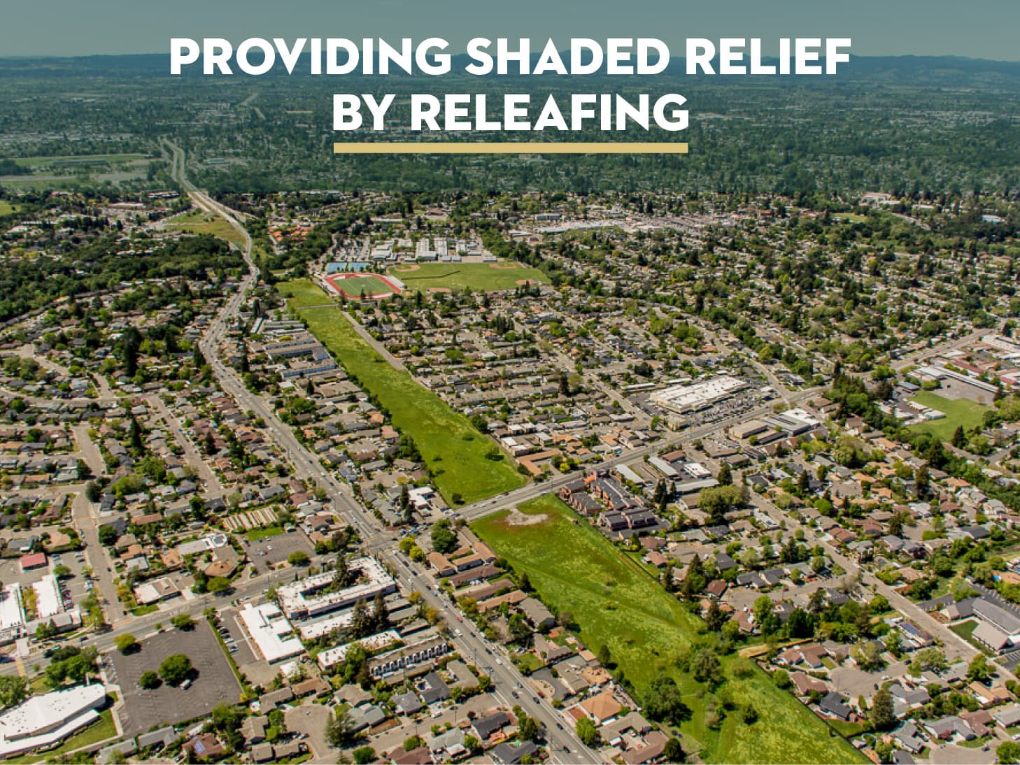
We often hear the term “infill” in reference to urban housing developments, but what if that same approach was applied to “infilling” our urban spaces with trees, plants, and water? Could we transform barren spaces into thriving ecosystems? Perhaps the answer can be found in the initial idea of transforming a vacant strip of land in the middle of Santa Rosa into a vibrant, green corridor, which provides the potential for this idea. Once planned as a four-lane extension of Highway 12, the Santa Rosa Southeast Greenway will reconnect neighborhoods with shade from trees, provide open space water catchment and storage, and increase access to cooler temperatures by naturally tempering an urban micro-climate.
What was once a dream shared by a handful of local residents has progressed into a vision for a central park that is now widely championed, and funded, by community members, local government, and agencies.
After more than a decade of planning, and spanning over 47-acres, this two-mile vacant corridor is finally on the home stretch to being transformed into a sprawling park in the heart of Sonoma County’s largest city – Santa Rosa!
The concept for greenways in American cities traces back to the 1800s with landscape plans that integrated natural spaces in urban environments being implemented across the country. But during the early part of the twentieth-century, Frederick Law Olmsted saw his once lauded idea for pedestrian greenways threatened by the automobile industry. As roads were laid down, they sliced paths through nature, disrupting the peaceful atmosphere of parks everywhere. Now, greenways across the country are reversing that paradigm by turning roads into green pedestrian pathways and removing barriers between communities.
Creating urban forests that shade homes and streets builds green connections that break up urban heat islands and provide numerous benefits. They create equitable access to cooler temperatures and decrease the risk of heat-related illnesses exacerbated by a warming climate. They lower temperatures in surrounding neighborhoods thereby decreasing utility costs associated with constantly running air conditioning units. And the mature trees produce clean air and water while at the same time capturing and storing carbon dioxide from our modern infrastructure. Greenways offer seemingly endless climate benefits including habitat for wildlife, spaces for outdoor education, room to recreate, pedestrian access to larger parks, and opportunities to come together with neighbors.
In the Sonoma County Climate Resilient Lands Strategy*, there is a check-list of criteria for projects like the Greenway that will help us build resilience and address rising temperatures through open spaces and parks.
“Developing green buffers with shade trees to provide relief from heat. Green buffers with shade trees around residential areas provide cooling while increasing permeable surfaces, which are important during rain events. Resilient lands – especially highly shaded lands and/or lands containing rivers, lakes, and coastline – provide residents with essential reprieves from heat.” (*excerpt from page 30)
Sonoma Land Trust is honored to play a role in the actualization of the Southeast Greenway and its timing could not be more needed as we seek solutions to a warming climate.
We would like to express our deepest sympathy to everyone who shares in the loss of Bob Gaiser, co-chair of the Southeast Greenway. We miss his wisdom, can-do attitude, warmth, and enthusiasm. He was a long-time partner and dear friend, and we reflect on all the good he did while he was with us and recognize that the Greenway will forever be tied to his legacy and lasting spirit. Thank you, Bob!

Join us in welcoming Shay Lozano to Sonoma Land Trust. Shay comes to us with a wide range of experience, including nonprofit program management, environmental restoration, land conservation planning, field data collection, and community health work. She was born and raised in Sonoma County and is excited to be working to support projects in her own backyard. A recent UC Davis grad with a BS in Environmental Policy Analysis and Planning, Shay bring data analysis, organization, and collaboration skills to her role on the philanthropy team. Along with her passion for natural resource conservation, Shay loves sewing, knitting, and taking walks with her dog.
Film screening, Conversation and Reception

Please join us, in collaboration with The Redford Center and Little Saint, for a public screening of Path of the Panther, directed by Eric Bendick. A 2020 Redford Center Grantee, this feature-length film spotlights the activists tracking and protecting the endangered Florida panther. Stunning images of the big cats spur a movement to restore a keystone species and dwindling wilderness.
The film will be screened on Tuesday, September 12 at 6:30pm at Little Saint in Healdsburg, and will be followed by a conversation on the power of impact storytelling and the growing movement to establish wildlife corridors. Hear from our own Eamon O’Byrne alongside Tori Linder (Path of the Panther) and Jill Tidman (The Redford Center), moderated by Jeffrey W. Ubben (Inclusive Capital Partners). A hosted reception will follow.
Please share this invitation with anyone who may be interested; we hope to see you on the 12th!
Upcoming Language of the Land:
Gardening for Wildlife
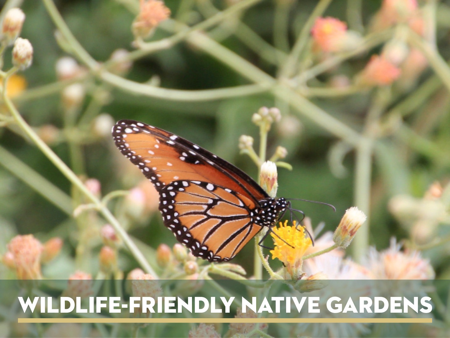
Wednesday, August 30, 7pm
Join us for a Language of the Land webinar featuring ideas for incorporating native plants into your home garden both for efficient use of water and to attract wildlife. Master Gardener Bill Klausing draws upon his own wildlife-friendly native garden at his home in Sonoma County to illustrate many of the possibilities available to home gardeners in the North Bay region.
https://sonomalandtrust.zoom.us/webinar/register/8216899184403/WN_CriXUMdBRUiMv4eWPxofWQ
Free Public Hikes in Partnership with Sonoma County Ag + Open Space
Creek Week Cleanup
Prince Memorial Greenway
Saturday, September 23, 9:30am-12:00pm
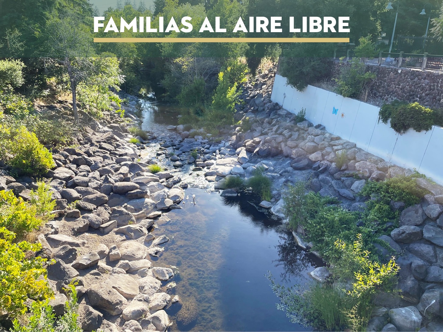
This month Sonoma Land Trust’s bilingual Families Outdoors will be participating in the City of Santa Rosa’s Creek Week cleanup! We will be picking up litter along the restored section of the Santa Rosa Creek at the Prince Memorial Greenway. There will be fun to be had in participating in the cleanup contests and prize giveaways organized by the City of Santa Rosa!
Level: Gentle
Limpieza para la semana de arroyos
Prince Memorial Greenway
Sabado, 23 de septiembre 9:30am-12pm
Este mes, el grupo bilingüe Familias al aire libre de Sonoma Land Trust participará en la limpieza de la Semana del arroyo de la ciudad de Santa Rosa. Estaremos recogiendo basura a lo largo de la sección restaurada del arroyo Santa Rosa en el Prince Memorial Greenway. ¡Nos divertiremos participando en los concursos de limpieza y sorteos de premios organizados por la ciudad de Santa Rosa!
Nivel: Suave
Raptor Walk
Jenner Headlands
Sunday, September 24, 10am-3pm
The Jenner Hawk Overlook is the spot to view the fall migration of raptors as they soar on the hillside updrafts along the Sonoma Coast. Join Sonoma Land Trust and Ag + Open Space on a hike from highway 1 to the overlook. Certified Naturalist Larry Broderick will introduce you to bird spotting and identification on location. We will walk approximately 4.5 miles with about 800 feet in elevation gain.
Level: Strenuous
Caminata de rapaces
Jenner Headlands
Sabado, 24 de septiembre 10am-3pm
El mirador Jenner Hawk es el lugar ideal para contemplar la migración otoñal de las rapaces mientras se elevan en las corrientes ascendentes de las laderas de la costa de Sonoma. Acompañe a Sonoma Land Trust y Ag + Open Space en una excursión desde Hwy 1 hasta el mirador. El naturalista Larry Broderick le introducirá en la observación e identificación de aves in situ. Caminaremos aproximadamente 4.5 millas con unos 800 pies de desnivel.
Nivel: Extenuante
There is no charge for these events, which are made possible by the voters of Sonoma County who fund the work of Ag + Open Space with a quarter-cent sales tax.
Estos eventos son gratuitos y son posibles gracias a los votantes del condado de Sonoma, que financian la labor de Ag + Open Space con un impuesto sobre las ventas de un cuarto de céntimo.

- Book: Not Too Late: Changing the Climate Story from Despair to Possibility by Rebecca Solnit and Thelma Young Lutunatabua
- Podcast: USGS Eyes on Earth Episode 55 – Urban Heat Islands of New York
- Video: How America’s hottest city is trying to cool down
- Webinar: Language of the Land: Garden for Wildlife
- TED Talk: Mapping Urban Heat Islands
- App: Oh Ranger! Park Finder