Press Release
Sonoma Land Trust uses nature-based solution to adapt to shoreline erosion and sea level rise
Oct 11, 2021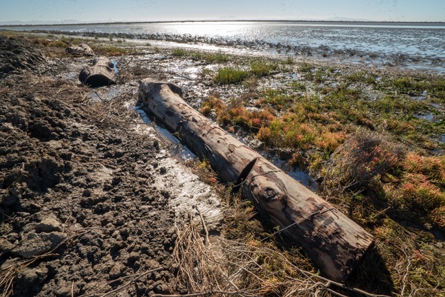
New “Living Shoreline” approach being pioneered at Sears Point Wetland Restoration using logs from Caltrans and PG&E to block levee erosion
In October, 2015, Sonoma Land Trust changed the map of San Francisco Bay by breaching the levee at its Sears Point Ranch along Highway 37 and letting in the tides for the first time in 140 years. With saltwater quickly filling the newly constructed 1,000-acre tidal marsh basin — one of the largest such projects in the Western U.S. — the primary goal was to restore the land that had been diked and drained for over a century back to tidal wetlands. These wetlands are crucial habitat and will also be critical for buffering infrastructure, like Highway 37, from the effects of climate-caused sea level rise.
The marsh is developing rapidly and most of the elements of this massive project are working well, with one exception. The 2.5-mile “habitat” levee, built to protect the surrounding lands from bay water and to provide high-tide refuge for marsh wildlife, is eroding along its shoreline. This is a common problem around the Bay where shorelines are exposed to wind waves — and it’s one that will worsen with sea level rise and also droughts, since most of the bay mud supply for tidal marsh growth comes from high flows of local tributary streams that discharge to the Bay.
To solve the erosion problem, Sonoma Land Trust is employing a unique combination of treatments that avoid “hardened” shorelines lined with boulders (known as rip-rap), which simply shifts the problem to other parts of the Bay. Instead, using natural materials, the goal is to create a “living shoreline” that will work with natural processes and achieve the intended ecological and flood protection benefits of the levee.
Causes of levee erosion
Marshes significantly reduce wave energy and where they have been lost or have not yet been fully restored, as at Sears Point, shoreline erosion is common. Erosion has occurred along approximately 8,000 feet of the northern, or habitat, levee, and roughly 1,300 feet of the western levee, which separates the earlier Sonoma Baylands restoration from the Sears Point project. If the erosion were to be left unchecked, it could threaten the stability of the flood protection functions of the northern levee and the public access trails of both the northern and western levees.
“Shoreline erosion like this is not uncommon, but how we’re approaching it is,” says Julian Meisler, Baylands program manager for Sonoma Land Trust. “For decades, it’s been dealt with by placing rock — static, unchanging rock — with no habitat value. Instead, we are using a dynamic solution: a unique combination of treatments that work together with natural tidal processes.”
“This project may be one of the first in the Bay region to combine the use of large woody debris, coarse and fine sediment, and natural processes, along with native vegetation, to address wind-wave erosion of recently restored, unstable tidal marsh and levee shorelines,” says Peter Baye, a coastal ecologist who co-designed the project. “This local tidal marsh variation on the ‘living shoreline’ approach to adaptive management will provide a large-scale test of the capacity of ’nature-based’ shoreline stabilization methods to provide an ecologically preferable alternative to engineered rip-rap, the traditional default response to shore erosion.”
How the “Living Shoreline” approach works
Working with a team of scientists and engineers, the Land Trust has developed a plan to adaptively manage the levee erosion with vegetation, logs, soil and the power of tidal currents. Several hundred logs that are 15−25 feet long will be strategically embedded and anchored in front of the levees to block wave energy and create a “wave shadow.” Historically, before the great Sacramento and San Joaquin Rivers were dammed and diverted, logs were a natural part of the system from treefall — and the Bay shoreline was a natural landing point. Today, obtaining logs and having them delivered is expensive, but Caltrans and PG&E responded to the call for help, bringing and stacking logs that they salvaged from road projects, burn areas and utility line clearing. Their contributions of logs and labor have saved Sonoma Land Trust $130,000 in costs. Siegel Environmental, the firm that developed the design, has been hired as the construction manager, Dixon Marine Services is the contractor and the Land Trust’s Meisler is serving as project manager.
Before installing the logs (which function similarly to large, woody debris in nature, it was first necessary to begin to stabilize the levee with native marsh plants. Over the past 18 months, crews transplanted 3,100 Pacific cordgrass plants along the front of the northern levee, which are growing well. Planting will continue this year and next. Ultimately, it is the cordgrass and other marsh plants that will provide the greatest shoreline defense.
The next step, which is currently in the beginning stage, is to place the logs by digging a trench and then positioning and anchoring a log in bay mud with smaller branches embedded underneath to reduce energy and trap sediment. The eroded scarp behind the logs will be graded to a gentle slope. Lastly, piles of granular, dried bay mud, of which 600 truckloads were brought in earlier from Port Sonoma, will be placed in between and in front of the logs so that the wind waves and tidal currents can wash them up on the shore in the form of swash bars, which are similar to gravel and sandbars on bay and lake shores. The swash bars will serve as platforms for pickleweed and other marsh species to colonize and take root and further stabilize the system. This local process was responsible for most of the high salt marsh that formed on the north shore of Sears Point in the first few years after tides were restored and it is copied in the “living shoreline” design.
“Our adaptive management approach is derived from natural processes observed by our design team onsite and around the bay,” concludes Meisler. “We’ll monitor its progress and, if we’re successful, we hope this will be a tool that other managers can use to manage the chronic issue of shoreline erosion within tidal marsh settings.”
Timing, funding and trail closure
The $900,000 project is expected to be completed by the end of this year. Funding has been provided by the California Wildlife Conservation Board.
Throughout the construction, which is anticipated to continue into December, the 2.4-mile Bay Trail–Eliot Trail and 0.3-mile Dickson Trail will be closed. The 1.4-mile Bay Trail–Sonoma Baylands Trail will remain open via Port Sonoma only.
# # #
About Sonoma Land Trust
Sonoma Land Trust works in alliance with nature to conserve and restore the integrity of the land with a focus on climate resiliency and is also committed to ensuring more equitable access to the outdoors. Since 1976, Sonoma Land Trust has protected 58,000 acres of scenic, natural, agricultural and open land for future generations. Sonoma Land Trust is the recipient of the 2019 Land Trust Alliance Award of Excellence and is accredited by the Land Trust Accreditation Commission. For more information, please visit www.sonomalandtrust.org.