Blog
from fire comes change
by Julian Meisler
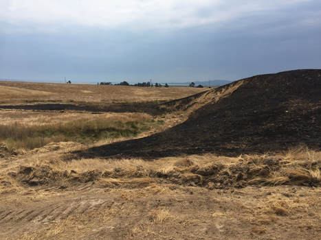
In August, a collision resulted in the downing of a power pole and the burning of about 30 acres at Sears Point. About 600 feet of fencing and fence posts will need to be replaced. To ensure that the fire did not spread even further, a fire break was bulldozed around the perimeter for about half a mile, plus more onto our neighbor’s property.
The cost is unfortunate, but we don’t fault the firefighters. They are only doing their job and we are grateful for them. Furthermore, the grassland is likely to benefit from the fire — it can play a vital role by clearing thatch and potentially destroying some of the non-native seed bank.
It will be interesting to watch the burn area through the spring to see what returns. We might see things we don’t want, like a line of yellow star thistle in the bulldozed firebreak, but we may also see germination of native grasses, like purple needle grass, meadow barley and creeping wild rye, as well as forbs like fiddleneck, lupine, checkerbloom and violets.
I happened to take some photos of the burn area last February as we evaluated it for future creek and wetland restoration. Last week, as I rode through the area on our ATV, I shot more photos; at least one photo lines up pretty well, offering a nice before and after of the burned acreage. Most interesting will be seeing what another photo will reveal next spring after the rains.