Blog
landscape/selfscape: reflections from above
by Crystal Simons
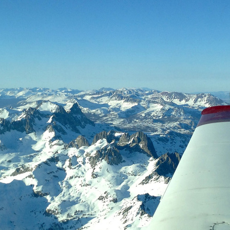
The Sierra Nevada from above.
The airplane’s wing blemished the edge of every photo I took with my smartphone that morning. Flying from the urban San Francisco Bay Area to my hometown in rural Idaho is a fairly simple affair. Three hours, two planes, one layover. And an infinite obsession with observing landscapes from above.
During takeoff, the East Bay hills drop from their place on the horizon and flatten into a quilt of rooftops and treetops. The rooftops reflect the sunrise and the treetops absorb the invisible CO2 emitted from the cars that move along the tangle of highways like tiny ants, obediently (or not) following the leader. As the plane travels east across the Central Valley and the California Delta, the highway network transforms into a complex but glistening system of distribution canals, reservoirs and surface waters. I’ve heard the Delta referred to as California’s lungs — a dynamic system that breathes water to and from one landscape to another by means of natural and manufactured arteries.
Lake Tahoe is easy to spot from above and, in my imagination, I can see the state line cutting across the landscape because I know that the political boundary exists. But the snow-capped Sierras are a more romantic indicator of the boundary between California and Nevada. I snap photos readily, eager for one to turn out abstract enough to appear artistic when I post it to my social media account, but also literal enough that a simple caption and hashtag (“Humbled by their purple mountain majesty. #SierraNevada #wilderness”) will draw the desired dose of jealousy from my friends and family: Hey everybody! Look! I’m on a plane, doing creative things and traveling somewhere magical. Ha! In reality, of course, I’m crammed into an economy seat on a battered regional jet at six in the morning wishing I was still in bed. But the continuity of the changing landscapes below keeps me and my addiction company.
Nevada is the most mountainous state in the U.S., and, from above, the dusty wrinkles of mountain ranges — not tall, but numerous — look aged and weathered from being at the bottom of an ancient sea for so many millennia. Their beauty is analogous to a National Geographic photo of an 80-year-old woman, her wrinkles deep and wise. As the plane descends into Salt Lake City for my transfer, I marvel at the vibrant primary-colored salt ponds dotted around the Great Salt Lake like speckles of paint on an eccentric artist’s palette. From my aerial vantage point, the landscape is especially beautiful when I zoom in so much that it becomes abstract.
But the landscape ecologist in me always zooms out for a realist perspective of connected systems. I follow the vibrant orange hue of the chemical-soaked salt pond to the bright green algae-soaked canal that disappears under another highway — this Utah thoroughfare has fewer ant-cars than in Oakland, but the air quality in the winter is worse because of inversion: the basin’s way of trapping smog in the cold air beneath a layer of hot air. For a moment, I’m distracted and think about how patterns of development and growth in the U.S. impact environmental policies that aim to protect air, water and landscapes. But then I snap back to the visibly tangible because if I daydream too long, the limited portal of the airplane window restricts my ability to see how one part of the landscape connects to another.
My eye follows the lonely Utah highway to the ribbon-like bow of interchanges. Another network of smaller roads leads to a distant but dominant pattern of golden and green swatches of irrigated farmland. This is the landscape of northern Utah and southern Idaho. Again, I imagine a state line, but this one is harder to place. The geography isn’t as obvious. Or, perhaps, the political boundary is a little more arbitrary? Some of the farmland swatches are square, diligently following a regular shape and size of so many Western land parcels, divided into a grid as the West was conquered by the steam engine. Others swatches are perfectly round, exposing the abundance of thirsty crops cultivated in a mountain desert that are so dependent upon the irrigation pivots rotating in a farmer’s field.
I hardly feel settled on the short flight from Salt Lake City to central Idaho when the pilot announces we’re preparing to land. The view below is imprinted on my soul. The twisting canyons, rivers and ridgelines of the Bitterroot, Sawtooth and Boulder mountain ranges comprise the landscape of my youth and I snap more photos, again failing to avoid the airplane wing.
As the baggage carousel rotates, I crop the airplane’s wing out of my photo of the snow-topped Sierra and click “share.” The photo doesn’t look as interesting as I hoped. It doesn’t convey the inquiry and depth I felt when scanning the ground from 30,000 feet above that morning. My attempt to articulate the intricacy and beauty of the connected landscapes is more of a monochromatic snapshot. It wouldn’t make a good postcard and I have a moment of regret for making it public. I’m grounded again, limited by my five-foot five-inch vantage point.
Crystal Simons is Sonoma Land Trust’s conservation easement program manager.
Epilogue: A series of landscape contemplations from above,
by the author during her travels at 30,000 feet.
by the author during her travels at 30,000 feet.

The town of Moron, Mongolia, from above.

Ecuador’s Mt. Chimborazo and alpine farming patterns on the equator, from above.

From above, the northern Mongolia mountains are strikingly similar to the foothills of central Idaho.

Rivers, roads, farms, fences and shadows in northern Mongolia.